
Deoban
Forest in Uttarakhand
2 posts
Guide from 2 posts by 2 creators
@triptight54, @thesphereticket
Loved by 2 creators
2 posts on Instagram.
Deoban is a high-altitude forest ridge situated in the Garhwal Himalayas of Uttarakhand, perched above the town of Chakrata. Known for its dense stands of ancient deodar trees and sweeping views of snow-capped Himalayan massifs, it offers a peaceful mountain retreat for nature lovers, birdwatchers, and trekkers. Travellers visit Deoban to experience untouched woodland trails, quiet campsites, and unhindered vantage points looking out towards the greater Himalayan range.
Getting there
By road
- From Dehradun3 hr 10 min · 104 km
- From Chandigarh5 hr 30 min · 211 km
- From New Delhi6 hr 25 min · 324 km
- From Ludhiana6 hr 55 min · 296 km
By train, bus or air
- Dehradun Train StationNearest railway station3 hr 10 min · 103 km
- Jolly Grant Airport - DehradunNearest airport3 hr 55 min · 130 km
Typical drive times without traffic. Places, distances and typical drive times from OLA Maps; notes from creators' Reels.
Deoban and Surrounds Itinerary
This itinerary explores the high-altitude trails and forests near Deoban and Chakrata, extending down toward the ridge viewpoints of Mussoorie and the valley attractions of Dehradun.
Chakrata and Deoban Highlands
Best for hikers and nature lovers exploring local trails and waterfalls
Day 1
Meadows, Caves, and Waterfalls
early_morning
Moila TopAbout 3 hr
Start the trek early in the morning to reach the summit and visit the traditional wooden temple. Note that camping is not permitted on the summit.
midday
Budher CavesAbout 2 hr · 100 m from the last stop
Explore the historic limestone cave network, which requires a 2.5 km trek.
afternoon
Tiger FallAbout 2 hr · 13 km from the last stop
Bathe or swim in the plunge pool beneath the waterfall. Proper swimming attire is mandatory, and carrying a change of clothes is recommended.
- Start the Moila Top trek early in the morning. Camping is prohibited at the summit, though allowed at the base.
- When visiting Tiger Fall, pack a spare set of clothes and wear proper swim attire, as bathing without clothes is strictly prohibited.
- Wear shoes with reliable grip when hiking George Everest Peak due to the steep, rocky trail.
- Visit Kempty Waterfall early in the morning during peak travel season to avoid massive traffic gridlocks and crowded pools.
Visit lengths are suggestions; distances are straight-line between stops.
About Deoban
Written with AI from creators' posts and map data. Check prices and timings locally before you go.
About Deoban
Deoban, whose name translates to the forest of gods, is set at an altitude of over 2,800 metres in the Chakrata region of Uttarakhand. The landscape is dominated by thick, pristine forests of Himalayan deodar, mixed with oak and rhododendron. Because of its elevation and dense tree canopy, the area retains a cool, alpine atmosphere even when the plains and lower foothill towns experience intense summer heat.
Historically part of the Jaunsar-Bawar cultural belt, the surrounding hills are steeped in local folklore and distinctive architectural traditions. Unlike bustling hill stations packed with commercial markets and crowded promenades, Deoban remains an understated wilderness destination where the rhythm of the day is governed by birdsong, mountain winds, and changing forest light. The ridge is especially valued by travellers seeking solitude, fresh mountain air, and clear panoramic views of high northern peaks.
Things to do in Deoban
Walking beneath the soaring canopy of giant deodars is the primary way to experience Deoban. Trails wind through deep woodland where sunlight filters through pine needles, offering an ideal setting for relaxed forest walks, nature photography, and quiet contemplation. Keep a lookout for local wildlife and varied bird species, including Himalayan monals, woodpeckers, and thrushes that thrive in these undisturbed canopies.
Trekking to nearby viewpoints rewards hikers with vistas extending to prominent peaks such as Bandarpoonch, Swargarohini, and the Chaukhamba range on clear days. Sunrise and sunset across these vantage points are particularly striking, turning the distant ice walls shades of amber and rose. Stargazing is another highlight; with minimal light pollution and thin mountain air, the night skies above Deoban reveal dense constellations and vibrant views of the Milky Way.
Read more
Places to visit around Deoban
The broader Chakrata area around Deoban offers several natural and cultural excursions within easy reach. Budher Caves and Moila Top, situated just about 7 kilometres away, are among the most popular day hikes. Moila Top is an expansive alpine meadow, while the subterranean limestone chambers of Budher Caves hold intrigue for adventurous explorers.
Tiger Fall, located around 6 kilometres from the ridge, is one of the highest direct waterfalls in Uttarakhand, plunging through a rocky gorge surrounded by lush vegetation. Chirmiri Peak, roughly 9 kilometres away, serves as another sweeping sunset point overlooking rolling ridgelines and Jaunsari valleys. For travellers extending their journey further towards Mussoorie and Devalsari, spots like Bhadraj Temple, Dalai Hills, and Kempty Waterfall offer varied landscapes ranging from oak forests to historic hillside trails.
Best time to visit Deoban
Deoban has distinct seasonal charms, with spring and early summer from April to June offering the most pleasant weather. During these months, daytime temperatures are mild, wild flowers bloom on the forest floor, and walking trails are entirely clear. It serves as an ideal refuge from the heat of northern plains.
The monsoon months of July and August bring heavy rain to the Garhwal hills. The forests turn vivid green, but rain-soaked dirt roads and lingering mountain mists can make travel slow and unpredictable. Autumn, from September through November, brings crisp air, golden sunlight, and the clearest mountain views of the entire year. By late December, winter arrives in full force, regularly blanketing the higher reaches of Deoban in thick snow. Winter travellers should be prepared for sub-zero night temperatures, frozen water lines, and occasional road closures.
How to reach Deoban
Deoban is reachable by road via Chakrata. From Dehradun, the journey covers roughly 104 kilometres and takes about 3 hours and 10 minutes under typical driving conditions. The road winds up through Vikas Nagar and Kalsi before climbing into the mountains towards Chakrata and the final forested stretch to Deoban.
Travellers driving from Chandigarh can expect a route of around 211 kilometres, which typically takes about 5 hours and 30 minutes. From Ludhiana, the drive is approximately 296 kilometres and takes around 6 hours and 50 minutes. If you are starting from New Delhi, the distance is around 323 kilometres, taking roughly 6 hours and 20 minutes along national and state highways. Private taxis and self-drive vehicles are the most convenient options, particularly for navigating the final unpaved forest track that leads up to the ridge.
Tips for your visit
Because Deoban sits well above standard hill station elevations, warm clothing is essential throughout the year. Even in peak summer, evening breezes can turn brisk, and a warm fleece or light jacket is recommended. In late autumn and winter, pack heavy woollens, thermal innerwear, gloves, and insulated jackets.
Amenities atop the ridge are sparse, with no large markets, fuel stations, or automated teller machines. It is wise to refuel your vehicle, withdraw needed cash, and stock up on personal medicines and basic snacks before leaving the lower towns. Mobile network connectivity can be patchy across the higher trails, so download offline maps in advance. Lastly, Deoban is an ecologically sensitive forest tract; please carry all non-biodegradable waste back down with you.
Where to stay in Deoban
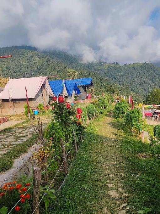
Staying near Deoban allows you to wake up inside deep pine woodland rather than inside a congested town. Accommodation choices across the ridge and surrounding valleys range from rustic campsites and eco-lodges to warm family-run homestays tucked into traditional mountain hamlets.
Campsites in the area let you pitch under towering deodars and enjoy campfires under starlit skies, while village homestays offer direct insight into local Jaunsari culture and home-cooked regional meals. You can explore and book verified camps, homestays, and outdoor getaways around Deoban on HireACamp.
Frequently asked questions
Does it snow in Deoban?
Yes, Deoban sits at an elevation over 2,800 metres and receives frequent snowfall during the winter months, typically between late December and February.
How far is Deoban from Chakrata?
Deoban is located about 11 to 13 kilometres uphill from the main market area of Chakrata along a winding forest road.
Can I visit Deoban on a day trip from Dehradun?
While a day trip is possible given the 3 to 4 hour drive from Dehradun, staying at least one night allows you to enjoy the high-altitude trails, sunsets, and star-filled skies without rushing.
Are there restaurants and shops at Deoban?
No, Deoban is a forested ridge with limited commercial infrastructure, so travellers should arrange food through their stays or carry essential provisions from Chakrata.
What kind of vehicle is suitable for reaching Deoban?
The road up to Chakrata is paved, but the final ascent to Deoban includes unpaved, rough forest stretches where a vehicle with good ground clearance is preferable, especially after rain or snow.
Where you'll be
1 stay nearby shown with prices
As seen on Instagram
The posts this guide is built from
Stays near Deoban
Book a place to stay close by
Things to do in Deoban
22 places creators recommend within 30 km


Often visited together
Creators who went here also showed these
Lists for this area
Ranked by how many creators recommend each place


Built from 2 Instagram posts by 2 creators. Every tip links back to the post it came from, and where creators disagree we show both sides.






